Bukhansan
Bukhansan Board


Bukhansan — A National Park You Climb from Downtown Seoul
Ask a Seoul-resident friend "Want to hike a mountain?" and the answer is usually Bukhansan or Cheonggyesan. Of the two, Bukhansan has the best routes for foreign travelers. Thirty minutes by subway, walkable as a flat trail without hiking boots, and if you go all the way to the top, a 360-degree view of Seoul. A no-regrets choice when you decide "I should hike a Korean mountain at least once."
What kind of mountain is it
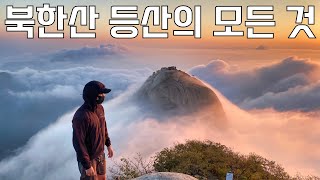
A national park of granite peaks rising north of Seoul. The highest point is Baegundae (836 m). Dozens of trails branch out, so you pick by fitness and time. Even weekdays have a steady crowd; on weekends, the summit literally has a queue — pick your day carefully.
Courses — pick by fitness
- 🟢 Dulle-gil (beginner) — any of the 21 segments works. Flat dirt path and forest. Sneakers are fine; no hiking boots needed. About 2–3 hours of easy walking. With a foreign companion, the Ui Dulle-gil ↔ Solbat Park segment has the best scenery.
- 🟡 Daenammun course (intermediate) — start at Gugi-dong → Daenammun → Bogukmun ridge. 4–5 hours. Temples and fortress walls in one route. Hiking boots required.
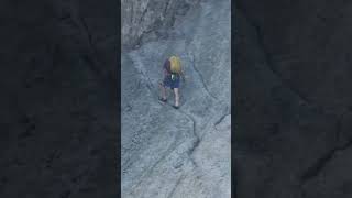
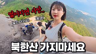
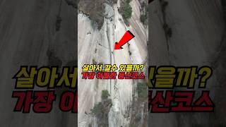
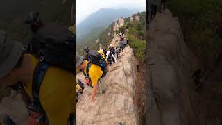
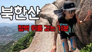
- 🔴 Baegundae summit (challenge) — start at Uidong terminus or near Doseonsa. Round trip 5–6 hours. The summit section has iron stairs and a chain rail on short rocky ridges. Doable for beginners but dangerous in rain or winter.
- 🔴 Uisang Ridge (expert) — rough rock-ridge traverse. Experienced hikers only.
Getting there
This is a mountain reached by subway, with multiple starting points.
- Dulle-gil — Suyu Station (Line 4), Hwagye or Solbat Park Station (Ui-Sinseol Line) all work as starts.
- Baegundae (summit) — From the Uidong bus terminus, take the Doseonsa shuttle or walk 30 min.
- Daenammun — From Gyeongbokgung Station (Line 3), take bus 7212 to the Gugi-dong terminus.
- Bukhansanseong — Gupabal Station (Line 3) Exit 1, then bus 704 or 34 to the fortress entrance.
Type "Bukhansan + entrance name" into KakaoMap or Naver Map; it'll route you immediately.
What you'll see from the top
From Baegundae — all of central Seoul to the south, Uijeongbu and Dobongsan to the north. Sharpest on a clear autumn morning. The summit selfie queue is long, so take the photo before lunch.
Food — the tofu village at the fortress entrance
Coming down the Bukhansanseong course, the tofu village at the fortress entrance is locally famous. Hand-made tofu, acorn jelly, makgeolli. After the hike, a bowl of makgeolli inside there tastes like real life. On the Uidong side, pine-nut noodles (jatguksu) are the specialty. Lined up with hiker restaurants — pick any, no big mistakes.
Season by season
- 🌸 Spring (Apr–May) — azaleas turning the ridges pink. The best time to climb.
- ☀️ Summer — valley hikes (Uidong, Jeongneung). Skip midday; go dawn to morning.
- 🍁 Autumn (late Oct–early Nov) — the peak season. The most crowded time of year.
- ❄️ Winter — snowscapes are stunning, but the summit rocks ice over. Stick to Dulle-gil.
Honest tips
- Bring 1 L of water minimum + snacks (chocolate, nuts). Shops are at the entrance only.
- Hiking boots recommended. Sneakers work for Dulle-gil but are unsafe higher up.
- Timing — for summit courses, start by noon at the latest. Descending after sunset is dangerous.
- Toilets at entrances and mid-route shelters only — almost none on the ridges.
- Mobile signal is weak at the summit. Agree on a meet-up point in advance.
Visitor info
- Admission: free (national park)
- Signage: Korean and English at every fork
- Emergency: 119, or call a shelter staff member
🗺 Map
Today's Videos
News


